Climate & Environment
NVCA adds 0.73 km² to Oak Street Canal floodplain map, meeting Nov. 5
The Nottawasaga Valley Conservation Authority says the updated model for the Collingwood canal increases mapped floodplain area by 0.73 square kilometres while removing 0.04 square kilometres. A public information meeting is set for Nov. 5 at Central Park Arena.
Utopia, ON
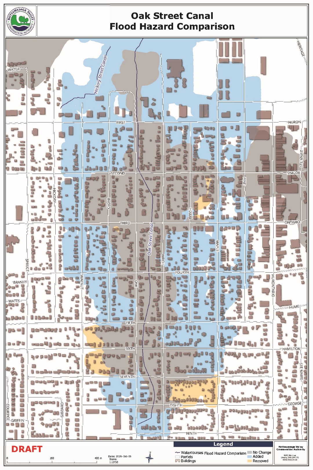
The Nottawasaga Valley Conservation Authority has increased the mapped floodplain area around the Oak Street Canal in the Town of Collingwood by 0.73 square kilometres, the conservation authority said in a release dated Oct. 7, 2026. The same update removes 0.04 square kilometres of previously mapped floodplain and confirms 0.47 square kilometres that was already mapped.1
The conservation authority will hold a Public Information Meeting on Thursday, Nov. 5, 2026, from 5:00 p.m. to 8:00 p.m. at the Central Park Arena, 85 Paterson Street in Collingwood. Attendees can hear a presentation from NVCA staff and ask questions about how the changes may affect their property.1
What the updated model shows
The Oak Street Canal carries stormwater from surrounding areas, starting just north of Ninth Street into Georgian Bay, according to Dalia Al-Ali, manager of engineering at NVCA. The updated model allows the authority to better assess the risk to people and property around the canal, she said.1
It shows us how water can move through the canal and spread across nearby lands, around roads, buildings, and other features, and it allows us to better assess the risk to people and property due to flooding.1Dalia Al-Ali, manager of engineering at the Nottawasaga Valley Conservation Authority
The floodplain generally extends from Ninth Street north to Georgian Bay, stretching east from Pine Street and Hurontario Street and west towards Walnut Street and Hickory Street, the conservation authority said. From the south, it begins at Ninth Street and extends to Georgian Bay.1
What the map change does and does not mean
The updated mapping does not mean the physical flood risk has suddenly changed, according to Michelle Schaefle, manager of development planning and permits at NVCA. Being within the updated floodplain also does not automatically prohibit development or improvements to an existing property, she said, though certain activities may require a permit and approval from NVCA.1
The updated mapping does not mean the physical flood risk has suddenly changed. Being within the updated floodplain also does not automatically prohibit development or improvements to an existing property. However, certain activities may require a permit and approval from NVCA.1Michelle Schaefle, manager of development planning and permits at the Nottawasaga Valley Conservation Authority
NVCA regulates development to help protect people and property from flooding and erosion, the authority said. Part of that work reviews development proposals and evaluates natural hazards to ensure development does not create or increase risks.1
Property owners looking to construct, reconstruct or change a site, building or structure in the Oak Street Canal floodplain are encouraged to contact NVCA early in the planning process. Staff can help confirm whether proposed work is affected by the updated regulated area and whether a permit may be required.1
More information about the Public Information Meeting is available at nvca.on.ca/oakstreetcanal, the conservation authority said. The NVCA describes itself as a public agency dedicated to the preservation of a healthy environment through specialized programs to protect, conserve and enhance water, wetlands, forests and lands.1
AI-assisted reporting under human editorial direction. Our editorial approach.
Evidence
This article was written from these documents, numbered as they are cited in the text. Each is the original release, notice, decision or dataset, not another outlet's report of it. Times shown are when Polaris retrieved each item, with the publisher's own date where it gave one.
- Nottawasaga Valley Conservation Authority NVCA invites residents to Public Information Meeting on updates to the Oak Street Canal floodplain map on November 5 Conservation authority Retrieved 8 Oct 2026, 15:15 UTC · published 7 Oct 2026
Comments
No comments yet.