Indigenous Affairs
Lil'wat Nation orders immediate evacuation along Lillooet River as flood risk rises
Chiefs and Council issued the order at 4 p.m. on Nov. 11, warning the river could reach 840 to 1,100 cubic metres per second and that the extent of flooding may not be clear until 3 to 5 a.m. Thursday.
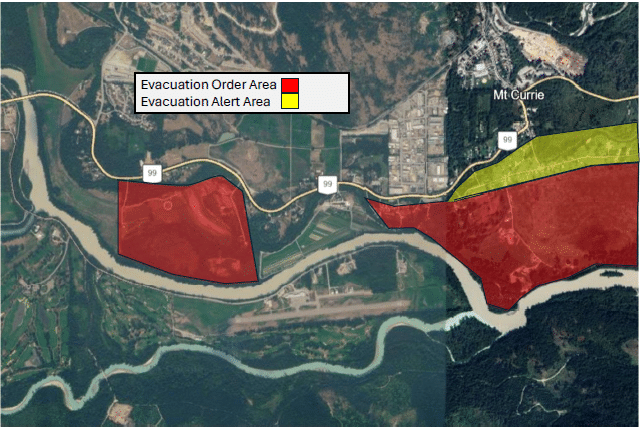
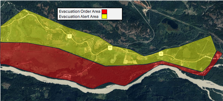
Lil'wat Nation (Mount Currie, B.C.) issued an evacuation order at 4 p.m. on Nov. 11 for everyone in a mapped area running from Kwetsa7 along the Lillooet River corridor to Lillooet Lake, citing the threat of flooding to life and safety. The order, authorized by Lil'wat Nation Chiefs and Council, applies to residents and visitors alike and expires at 4 p.m. on Nov. 18 unless rescinded or extended.1
The Nation said the latest forecasts indicate the Lillooet River could reach approximately 840 to 1,100 cubic metres per second, with water expected to overflow into some low-lying areas. River levels are expected to rise throughout the night and into the next morning, and the extent and location of flooding may not become clear until approximately 3 to 5 a.m. on Thursday, Nov. 12.1
Chief and Council said they decided to act early to give people time to leave safely rather than risk an evacuation in darkness as water rises. "Do not wait for water to reach your property or for someone to come to your door," the order states.1
Begin evacuating immediately. Do not wait for water to reach your property or for someone to come to your door.1Lil'wat Nation Chiefs and Council, evacuation order
Evacuees are directed to the Úll̓us Community Complex at 82 IR #10 Road in Mount Currie, where Emergency Social Services will provide registration, refuge and assistance. Joanne John will coordinate accommodation and transportation assistance, and anyone who needs help leaving home can call 604-895-6115. The Nation asked people to register even if they plan to stay with family or friends, so it knows they have somewhere safe to go.1
The order tells people to take essential medications, identification, phones and chargers, warm clothing, and supplies for children and pets, and to bring pets where possible using carriers or leashes. Major evacuation routes are not currently expected to be affected, but the Nation warned conditions can change and said people should not drive or walk through floodwater. It also said not to delay leaving to protect belongings or finish sandbagging.1
Members of the Stl'atl'imx Tribal Police and volunteers will go door to door to notify people and help with evacuation, and the Emergency Operations Centre is open and supporting the response. General information about the evacuation is available on the Lil'wat Nation public information line at 604-894-6115, and updates will be posted on the Nation's website and Facebook page.1
The order divides the mapped area into red zones, where people must evacuate immediately, and yellow zones, where people must be ready to leave on short notice. The attached map forms part of the order. The Nation said no one should return to the evacuation area until it confirms the area is safe and authorizes re-entry.1
Prepared with reporting tools under our editorial standards. Our editorial approach.
Sources
- Evacuation Alert & Order, November 11, 2026 · Lil'wat Nation
Comments
No comments yet.